Argentina Part I:
Patagonia to Ushuaia:
(14 December to 8 January 2009)
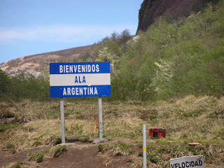
Crossing into Argentina was easier than any border crossing we have experienced. Even the pet paperwork took only 15 minutes. The actual border between Chile and Argentina is in the Andes Mountains (Figure 1 & 2). We drove immediately to San Carlos de Bariloche on the shores of Lago Nahuel Huapi (Figure 3, also called Lago Bariloche).(14 December to 8 January 2009)
Figure 1. The border between Chile and Argentina.
Figure 2. The pass in the Andes between Chile and Argentina.
Figure 3. Lago Nahuel Huapi defines the north side of San Carlos de Bariloche.
We spend the first two days at a nice, but uninteresting, campground a few kilometers west of Bariloche, Camping El Yeti (Figure 4). During these first two days I meet Juan Waroquieres, a fishing guide at Petunia Campground (Figure 5). He talks us into staying at the cabañas at Petunia (Figure 6). The cabañas are nice and have beautiful views (Figure 7). Juan also owns the small but excellent gourmet restaurant, Puerto Petunia (Figure 8).
Figure 4. Our camp at El Yeti.
Figure 5. My fishing guide, Juan, from Fishing Patagonia.
Figure 6. Our cabin at Petunia.
Figure 7. The view from our cabin at Puerto Petunia.
Figure 8. The Restaurant Puerto Petunia.
I hire Juan to take me trout fishing on Lago Nahuel Huapi. I am told by an expert fly fisherman that Juan is probably the best guide in Bariloche. We go for two trips, a couple of hours each on two consecutive days. The first day I catch four trout. The sizes range from 22 inches (about 2 kg, 4.5 lbs) to 24 inches (3 kg, 7 lbs). They are all rainbows, and we keep two (Figures 9 & 10). The second day Juan promises me a German brown trout. We fish for several hours and take two nice rainbows that I release. On our last pass along the north side of Peninsula San Pedro, I get a hit that really bends the rod. It is a 27 inch, 4 kg (about 9 lbs) German brown (Figures 11 & 12).
Figure 9. One of the rainbows I release, it is 22.5 inches.
Figure 10. This one, 24 inches, I keep to have smoked.
Figure 11. German brown trout, I cannot smile because it weighs so much it is hard to hold.
Figure 12. The German brown puts up a good fight.
We spend Christmas in Club Hotel Catedral, the ski resort at Bariloche. Gary and Karla meet us on the 23rd. We have a nice Christmas day dinner of trout, fondue, and Argentine wine (Figures 13 & 14).
Figure 13. Christmas dinner of trout and wine.
Figure 14. Sharon, Karla, and Gary at the fondue pot.
We leave Bariloche on 26 December to head south on famous Ruta 40 through Patagonia. The first night brings us to a small town in Patagonia called Epuyen (Figure 15). We have a nice dinner at Refugio del Lago (Figure 16).
Figure 15. Sharon and John at Lago Epuyen.
Figure 16. Gary, Karla, and Sharon at dinner in Refugio del Lago, Epuyen.
The next day, we enter Parque Nacional Los Alerces (Figure 17). It has stunning Nothofagus (southern beech) forests (Figure 18) and fine fishing, although the rainbows are small (Figure 19).
Figure 17. Parque Nacional Los Alerces.
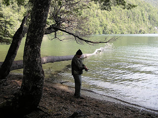
Figure 18. Gary with fly rod in hand contemplates the southern beech forest at Los Alerces.
Figure 19. John fishing at Los Alerces, Lago Rivadiva.
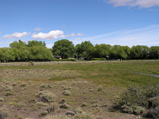
Out of Los Alerces, we take Ruta 40 south in the Province of Chubut (Figure 20). The scenery looks very much like the Great Basin in north central Nevada (Figure 21). The road is paved until Rio Mayo where it turns to ripio (graded dirt) for over 500 km. We camp at two Estancias along the way south. These are working sheep/cattle ranches that also take in tourists. They are quite nice and the views are fantastic (Figures 23 to 26). Wildlife is easy to see on the estancias (Figures 27 to 32).
Figure 20. Sharon and MB on Ruta 40 out of Gobernador Costa.
Figure 21. The landscape along Basin Ruta 40 reminds one of the Great Basin in North America.
Figure 22. Ruta 40 is ripio (dirt) south of Rio Mayo.
Figure 23. Camp at Estancia Telken.
Figure 24. Estancia Tellken.
Figure 25. John at breakfast at Estancia La Angostura.
Figure 26. A view of Estancia la Angostura.
Figure 27. Crested duck at Estancia la Angostura.
Figure 28. Long-tailed meadowlark at Estancia La Angostura.
Figure 29. Black-necked swan at Estancia La Angostura.
Figure 30. Upland goose (male) at Estancia La Angostura.
Figure 31. Guanaco at Estancia Telken.
Figure 32. Lesser Rhea with chicks at Estancia Telken.
The landscape is mesmerizing as we travel Ruta 40 south (Figures 33 to 35). As we approach El Calafate and Glacier Perito Moreno, the landscape becomes more varied (Figures 36 & 37). Glacier Perito Moreno is a real tourist attraction (Figures 38 &39).
Figure 33. Landscape south of Estancia Tellken.
Figure 34. South of Estancia Tellken, Los Andes in the background.
Figure 35. Hills south of Estancia La Angostura.
Figure 36. An iceberg is visible on Lago Argentina. It was probably calved from Glacier Perito Moreno.
Figure 37. Lago Argentina west of El Calafate with Los Andes in the background.
Figure 38. Glacier Perito Moreno.
Figure 39. Glacier Perito Moreno calves.
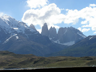
On 2 January 2010 we leave Argentina for Chile (Figure 40). Regardless of the reason, we would have to cross into Chile in any event. This is a short diversion to see Parque Nacional Torres del Paine (Figures 41 to 43). And the park also has some spectacular wildlife (Figures 44 to 49).
Figure 40. Chilean border with Argentina, the only way into Torres del Paine (and Tierra del Fuego) without boating or flying.
Figure 41. Part of the reason for the name, "Torres del Paine".
Figure 42. Another reason for the name, Torres del Paine.
Figure 43. Salto Grande (Great Falls) at Torres del Paine.
Figure 44. Patagonian grey fox in Torres del Paine.

Figure 45. Crested cara cara in Torres del Paine.
Figure 46. Andean Condors in Torres del Paine.
Figure 47. Guanacos in Torres del Paine.
Figure 48. White-eared grebe in Torres del Paine.
Figure 49. Flying steamer duck in Torres del Paine.
The road leads south to Puerto Natales and on to Punta Arenas where we camp for two nights (Figure 50) before taking the ferry across the Straights of Magellan (Figures 51 to 53). Of course, once on Tierra del Fuego, we had to cross back into Argentina (Figure 54). Our first night in Tierra del Fuego, we stay in the town of Rio Grande. We find a nice campground at the Club Nautica, which is a kayaking business (Figure 55 & 56). Interestingly, we meet two men from California (one from Santa Cruz) who began their trip on bicycles in 2006. They started in Deadhorse Alaska. It’s a small World.
Figure 50. Camp at Punta Arenas.
Figure 51. The ferry from Punta Arenas to Porvenir across the Straights of Magellan.
Figure 52. Crossing the Straights of Magellan.
Figure 53. The Straights of Magellan with Tierra del Fuego in the background.
Figure 54. The Argentine border in Tierra del Fuego.
Figure 55. Camp at Club Nautica in Rio Grande.
Figure 56. Sharon in the dinning room at Club Nautica.
From Rio Grande we take Ruta 3 south to Ushuaia (Figure 57). We finish the first part of Argentina in Ushuaia. This is our ultimate destination (Figures 58). It is now our objective to return home. The city of Ushuaia is the starting point for most cruises to Antarctica (Figure 59). Our camp is comfortable in Ushuaia (Figures 60 & 61) at coordinates S 54° 48.780’ X W 68° 21.102’. Gary, Karla, Sharon and I celebrate reaching the end of the driving World (Figures 62 & 63). Actually, the road continues on southwest to Lapataia at coordinates S 54° 49.873’ X W 68° 33.875’. One might be able to make the case that the road to Punta Arenas, Chile is as far south as you can drive, since you have to cross an ocean waterway (the Straights of Magellan) to get to Tierra del Fuego.
Figure 57. Tierra del Fuego, Ruta 3 to Ushuaia.
Figure 58. We are at the doorstep to Ushuaia.
Figure 59. Ships in the port at Usuaia.
Figure 60. Ushuaia campground.
Figure 61. Our camp at Ushuaia.
Figure 62. Celebrating reaching our goal with Argentine "champagne" at camp.
Figure 63. Even the car enters the celebration.
The entire trip from Deadhorse to Ushuaia included a total of 20,172 miles (32464 km). Now we will head back north. The Mercedes completed this leg of the trip with one blow-out, a worn universal joint, and one head light replaced.
Argentina Part I: Patagonia is, perhaps, the most interesting segment of our road trip (2345 miles recorded in Argentina and the detour to Torres del Paine). Ushuaia was our destination.


+souith+of+Rio+Mayo..JPG)


+at+Estancia+La+Angostura..JPG)


+at+Torres+del+Paine..JPG)


No comments:
Post a Comment