Monday, April 19, 2010

Chile Part II

Chile II:
After the Earthquake:
(22 March – 13 April 2010)

Our border crossing into Chile was interesting. While we tried to cross on 20 March, we were denied entry by the agricultural inspector who wanted more health papers on Amadeus. When we returned on 22 March a different agriculture inspector was not even interested. In any event we crossed into Chile without problems and stayed in Pucón, a small town at the base of Volcán Villarica and along the shore of Lago Villarica (Figures 1 to 3).

Figure 1. Pucón with Volcán Villaricva in the background.


Figure 2. Volcán Villarica from Pucón, the volcano is active.


Figure 3. Pucon also lies along the shore of Lago Villarica.


Pucón is a relatively famous area for fishing and skiing. While I did not fish because the weather was poor, we did visit the ski area on the slopes of Volcán Villarica (Figures 4 to 6).

Figure 4. The ski resort at Pucón.


\


Figure 5. The lodge at the ski Resort at Pucón


Figure 6. In the off season people climb Volcán Villarica (see the dots).


After two days of bad weather (a lot of rain), we drive on to Ruta 5 (the Panamerican Highway). We drive through a lot of areas that were affected by the 8.8 earthquake that struck Chile on the 28th of February. There were bridges down, houses in ruins, and buildings damaged. To the credit of the Chilean people, by mid-March, much of the damaged had been cleaned-up and repairs were in progress. We took only a few photos (Figures 7 to 9).

Figure 7. Damage to buildings in the small town of Peralillo in the Colchagua Valley.


Figure 8. Earthquake damage to the church in Santa Cruz.


Figure 9. Earthquake damage in Santa Cruz.


We drove west to the famous surfing town of Pichilemu on the coast. There was very little earthquake damage in this town. The beaches look much like those in California (Figure 10 & 11). There were only a few surfers in the water (Figure 12). The sea birds were spectacular (Figures 13 & 14).

Figure 10. The beach at Pichilemu.


Figure 11. The surf at Punta Lobos, Pichilemu.


Figure 12. Surfers inb the water at Punta Lobos, Pichilemu.


Figure 13. Peruvian pelicans at Punta Lobos, Pichilemu.


Figure 14. Pelicans, cormorants, gulls, and boobies can vbe seen on this rock off Punta Lobos, Pichilemu.


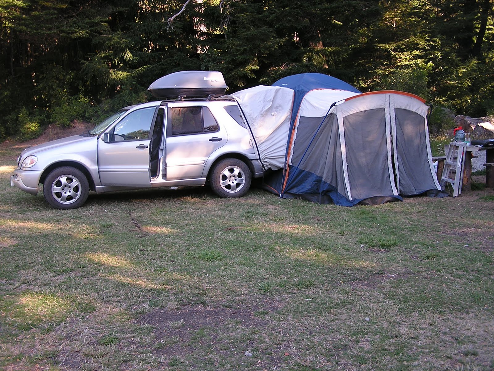
We drove on to the Colbún Reservoir just east of Talca and Ruta 5. We camped at a “closed” campground (Figures 15 & 16).

Figure 15. Sharon at our camp at Embalme Colbún.


Figure 16. Embalme Colbún in a Chaparral habitat.


We drove further east to Reserva Nacional Alto Lircay. It is a large stand of cöigue (Nothofagus dombeyi) and roble (N. macrocarpa), (Figures 17 & 18). We had the park all to ourselves (Figure 19). We stayed 3 nights and did a lot of hiking (Figures 20 to 23). We saw a variety of wildlife or their sign (Figures 24 to 27)

Figure 17. Cöigue in Reserva Nacional Alto Lircay.


Figure 18. Roble in Reserva Nacional Alto Lircay.


Figure 19. Our camp in Alto Lircay.


Figure 20. Hiking the trails in Reserva Nacional Alto Lircay.


Figure 21. View across Valle Venado in RN Alto Lircay.


Figure 22. View of the ridge above camp in RN Alto Lircay.


Figure 23. Cöigue forest in RN Alto Lircay.


Figure 24. Unidentified hawk in RN Alto Lircay.


Figure 25. White-throated treeclimber in RN lto Lircay.


Figure 26. An interesting fungus in RN Alto Lircay.


Figure 27. Degu (Octodon sp.) burrows in RN Alto Lircay.


Figure 28. Fox scat with berries in RN Alto Lircay.


After three nights we drove north toward Santiiago. We found a Boy Scout Jamboree camp (Parque Picarquin) that allowed us to camp for the night. The park was almost deserted. We stayed only one night, but the area is interesting (Figures 29 to 32). In the Southern Hemisphere things are reversed from up north (Figure 33 & 34).

Figure 29. Fixing dinner at Picarquin Dinner.


Figure 30. Puff ball on the lawn at Picarquin.


Figure 31. Another mushroom at Picarquin.


Figure 32. The moon is full at our Picarquin camp.


Figure 33. North facing slope.


Figure 34. South facing slope.


We went on north and east of Santiago to the valley of the Rio Maipo (Figures 35 & 36) where we camp for two nights.

Figure 35. Our camp at Cascadas de Animas on the Rio Maipo.


Figure 36. The Rio Maipo is famous for its white water rafting.


We drive to Viña del Mar to stay while we wait to ship our car. We visit Valparaiso (Figures 37 to 41). While here we drive east over the hill to the wine region of the Casablanca Valley (Figures 42 to 44).

Figure 37. The harbor at Valparaiso from Restaurant Turri on the hill.


Figure 38. The Bohemian area of Valparaiso where many artists try to make it.


Figure 39. Another artist shows her work.


Figure 40. We take the funicular to climb the hills of Valparaiso.


Figure 41. Of course lunch at Restaurant Turri includes wine.


Figure 42. Vineyards in Casablanca Valley from Viña Indomita.


Figure 43. Lunch at Viña Indomita, I have pulpo (octopus).


Figure 44. Sharon tastes a nice Pinot Noir at Vina Indomita.


After we leave the car in Valparaiso (it is now two weeks late in shipping), we go on to Santiago (Figures 45 to 48).

Figure 45. Outside our hotel in the Providencia region of Santiago.


Figure 46. Santiago is quite modern with many skyscrapers.


Figure 47. Another skyscraper.


Figure 48. Windows need to be washed.


Again, Chile was a pleasant country to visit. We only hope the car gets to Houston on time.

Friday, April 16, 2010

Halfway Around the World: The Journey of a Cat Called Amadeus and a Dog Called Ewok from Deadhorse Alaska to Ushuaia, Argentina

We have usually traveled with our pets (Amadeus & Ewok) and so when we decided to do the Las Américas Trip we knew they would do the trip with us. Amadeus and Ewok had traveled internationally before (Canada, Mexico, Guatemala and Honduras) so we were aware there would be challenges such as border crossings, finding pet friendly accommodations and changing climatic conditions. We also worried about the fact that they were both 15 years old. We arrived in Deadhorse, Alaska just in time for the Summer Solstice, June 21, 2009 and then headed south through Canada, United States, Mexico, Central and South America. We completed our Deadhorse, Alaska to Ushuaia, Tierra Del Fuego, Argentina Journey on January 6th, 2010 (just after the Summer Solstice in the Southern Hemisphere).

After we reached Ushuaia we returned to Punta Arenas, Chile for 6 days to receive cancer treatment for Ewok from caring Dr. Tatiana Lopez. We returned to Bariloche, Argentina where our beloved Ewok died on January 18th. Amadeus, John and I miss her. She was a very special dog. Just showing her photo on my i-phone got us at a hotel room at many places that would not normally accept dogs.

We shipped our SUV from Valparaiso, Chile early April. Our plans are to stay in South America until May 10, 2010. Amadeus flew on LAN Chile from Santiago to Buenos Aires on April 13th and later will fly to the US on Continental Airlines. His summer travel plans include British Columbia and Guatemala.

This i-movie covers the journey of “a cat called Amadeus” and “a dog called Ewok” from Deadhorse Alaska to Ushuaia, Argentina.

Sharon,
Santiago, Chile
April 13, 2010


Saturday, April 3, 2010

Argentina Part V

Argentina Part V:
A Return to the Lake Region:
(1 to 22 March 2010)


After leaving Córdoba, we drive a short distance to La Cumbre in the Central Sierra. La Cumbre is a small town where we camped for two nights (Figure 1). The second night we had a rain storm that lasted all night, thus the extra tarp over the tent. However, the rain did bring out the birds (Figures 2 to 5).

Figure 1. Camp at La Cumbre.


Figure 2. Unidentified falcon at La Cumbre.


Figure 3. Field Flicker at La Cumbre, it is one the largest flickers I have ever seen.


Figure 4. Great Pampa Finch at La Cumbre.


Figure 5. Spot-winged Pigeon at La Cumbre.


La Cumbre is also a major paragliding area. The World Championships were held here in 2003. While we were at the cliffs there were several paragliders (Figures 6 & 7). The view from the cliffs overlooks a large cut of Pampas (Figure 8).


Figure 6. Paragliders at La Cumbre, one is a passenger. The other is the "pilot".


Figure 7. Paraglider just getting started.


Figure 8. View of the Pampa from near La Cumbre.


We leave La Cumbre, but do not get very far. We stop for two nights in the ACA (Automovil Club de Argentina) Campground at Villa Carlos Paz. The bird life is fantastic (Figures 9 to 14).


Figure 9. Green-barred Woodpecker in campground.


Figure 10. Shiny cowbird at camp.


Figure 11. Brown Cacholote in camp.


Figure 12. Scimitar-billed Woodcreeper.


Figure 13. Monk Parakeet.


Figure 14. Monk Parakeets in nest, they are colonial with up to 50 living in one nest.


We take Ruta 35 south through the province of La Pampa (Figure 15). The region is mostly grasslands, pampas (Figures 16 to 18), but there are a few animals to be seen (Figures 19 to 21).

Figure 15. Ruta 35 traverses most of the province of La Pampa.


Figure 16. Grasslands in La Pampa.


Figure 17. Pampas grass in the pampas.


Figure 18. Ruta 152 goes west through the pampas. The road is lined with mustard.


Figure 19. Back end of an armadillo in the pampas.


Figure 20. Birds of prey are common, but seldom sit still for a photo.


Figure 21. White-faced tree ducks in a roadside pool.


We head west on Ruta 152 which passes the small national park, Parque Nacional Lihué Calel (Figure 22). This a small area of desert scrub in the midst of the pampas. There are interesting plants (Figures 23 to 27) and animals (Figures 28 & 29). This trail leads to a set of rock paintings (Figures 30 to 32).

Figure 22. Entrance to Parque Nacional Lihué Calel.


Figure 23. One of many cactus in the park.


Figure 24. A prickly pear cactus that looks much like the ones we have.


Figure 25.  A cactus in flower.


Figure 26. Lichens on granite.


Figure 27. Vegetation along a permanent stream.


Figure 28. Patagonian grey fox.


Figure 29. Male guanaco keeping watch over his harem.


Figure 30. Pinturas (rock paintings) by indigenous people of the area.


Figure 31. Some pinturas are abstract designs.


Figure 32. Other pinturas are of various animals, like this fox.


We finally approach the Lake Region on Ruta 40.and the base of the Andes (Figure 33). We stay for several days in a campground at Villa La Angostura on the north side of Lago Nahuel Huapi (Figure 34). At camp we adopt a young chimango caracara, who begs food from us every morning and evening (Figure 35).

Figure 33. A mountain caracara induicates we are approaching the Andes.


Figure 34. Camp at La Angostura.


Figure 35. Chimango caracara we nickname Chimi.


While in La Angostura, we take a boat trip to the Parque Nacional Arrayanes which is on a peninsula of Lago Nahuel Huapi (Figures 36 & 37). The park is named for its stand of arrayanes (Luma apiculata) trees. This is one of the few areas where there is a large stand of the trees (Figures 38 & 39). There is also a nice forest of southern beech (Nothofagus dombeyi) (Figure 40).

Figure 36. Sharon on the catamaran to PN Arrayanes.


Figure 37. Shoreline along the peninsula.


Figure 38. Arrayanes trees, notice the unusual bark.


Figure 39. Close up of trunk of an arrayan tree.


Figure 40. Southern beech is the dominant tree in this forest.


We leave via Ruta 234 which is a dirt road that is also called “El Camino de Siete Lagos” (Road of the Seven Lakes). Obviously, it passes by seven lakes, this is one of them (Figure 41). We camp at Lago Falkner (Figures 42 & 43).

Figure 41. Lago Falkner is one of seven lakes we pass.


Figure 42. Sharon studies our route while camped at Lago Falkner.


Figure 43. The mountains above Lago Falkner and our camp.


The small village of San Martin de los Andes lies at the northern end of “El Camino de Siete Lagos” (Figure 44). We stay in a nice complex above the town (Figure 45). The town is famous for its world class ski resort at Chapelco (Figure 46) and for fishing Figure 47 & 48).

Figure 44. The main street in San Martin.


Figure 45. View from our cabin at Villa Pirén above San Martin.


Figure 46. Chapelco Ski Resort a few kilometers south of San Martin.


Figure 47. View of Lago Lacar a favorite fishing lake in the area.


Figure 48. Fly fishing on Rio Malleo.


After a week in San Martin, we head for the Chilean border. We get to see some nice wildlife and scenery on the way (Figures 49 to 55).

Figure 49. Patagonia red fox along Ruta 60 heading to the Chilean border.


Figure 50. A flock of austral parakeets flies overhead on Ruta 60.


Figure 51. Araucaria forest in Parque Nacional Lanin.


Figure 52. Volcan Lanin covered in clouds.


Figure 53. Volcan Lanin seen from Ruta 40 as in Argentina Part III.


Figure 54. Rainbow below Volcan Lanin.


Figure 55. Guacho, horse, and dog on Ruta 60.


We try to cross into Chile at Paso Mamuil Mala (Paso Tromen). The Chilean Agricultural Inspector would not allow us to go into Chile with Amadeus. He said we need more health documentation. We have used the same docs for the past six entries into Chile. This is a very small dirt road crossing, and, I guess the inspector wanted to show he was "in charge". We had no choice but to return to San Martin and get a veterinarian to issue new docs. Now we have to wait until Monday to get the Agricultural agency for Argentina to give us another health document. This has cost us two days travel time, and two night’s hotel. Two days later we cross into Chile (Figure 56). When we did return with the proper documentation, another inspector was not very interested in the paperwork. He just laughed when we told him what the other inspector said.

Figure 56. Crossing into Chile.


Thus, we end our motor trip in Argentina. We were in country for over three and a half months, and recorded over 12,000 miles (19,200 km) in country. This has been an amazing part of our trip. We will return to Buenos Aires after we ship our car from Valparaiso, Chile.
Search Amazon.com for argentina travel guide